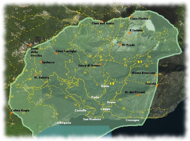
There are 3 main hiking routes to enjoy in the territory of Valsolda:
ROUTE 1: in the bear’s cave:
Recommended period: from March to December
Vertical Drop:730 m
Travel time: 4 hours for the whole trip Difficulty: E = Excursionist
Starting point : Dasio 580 m, reached by leaving the road SS 340 of the Valley of Menaggio between
Cressogno and S.Mamete, and following the road towords Loggio, Drano, Puria and Dasio.
Pedestrian routes: Follow the footpath “Sentiero delle 4 valli” n ° 1 to Alpe Serte, then follow n ° 25 till
Alpe Mapell and finally take n ° 5 till the Cave.
The route:
Park your car in the carpark in front of the church of Dasio. Climb up the steps front of the church and
enter the village. After a few paces you will find a sign indicating the path “Sentiero delle 4 valli”, which
tells you the direction. After crossing the wooden bridge, turn left and begin the climb. Follow signs
through the natural reserve towords Alpe Serte. Follow the path number 25 turning left, cross the river and
through the woods and climb to Alpe Mapell. Here you can admire the view of the valley. Finally follow
the path number 5 to the Bear’s Cave.
ROUTE 2: the natural reserve
Recommended period: from March to December
Vertical Drop: 620 m
Travel time: 4 hours for the whole trip
Difficulty: E = Excursionist
Starting point : Dasio 580 m, reached by leaving the road SS 340, between Cressogno and S.Mamete,
and following the road towords Loggio, Drano, Puria and Dasio.
Pedestrian routes: Follow the footpath “Sentiero delle 4 valli” n ° 1 to Alpe Serte, then follow the red or
the blue signs, throught the reserve.
The route:
Park your car in the parking in front of the church of Dasio. Climb up the steps front of the church and
enter the village. After a few paces you will find a sign indicating the path “Sentiero delle 4 valli”, which
tells you the direction. After crossing the wooden bridge, turn left and begin the climb. Follow signs
through the natural reserve towords Alpe Serte. Here begin the trip through the natural reserve. Follow the blue or the red paths.
ROUTE 3: Monte Pizzoni
Recommended period: Summer
Vertical Drop: 830 m
Travel time: 5-6 hours for the whole trip
Difficulty: EE = Attention for expert excursionist
Starting point : Drano 470 m, reached by leaving the road SS 340 of the Valley of Menaggio between
Cressogno and S.Mamete, and following the road towords Loggio, Drano, Puria and Dasio.
Pedestrian routes: Follow the footpath n°2 “Via per Rancò”, then follow n° 32 and then n° 30 till the top
of Monte Pizzoni.
The route:
Park your car in the parking of Drano. Follow the Street “Via dell’eroismo” and enter the village. Follow
the path n°2 “Via per Rancò”. After a few paces you will find a sign indicating the path n° 32 and n°30.
Turn right and begin the climb. Follow the path till the top. Pay attention to the weather forecast, this is a very difficult trip
